Geospatial Data Management
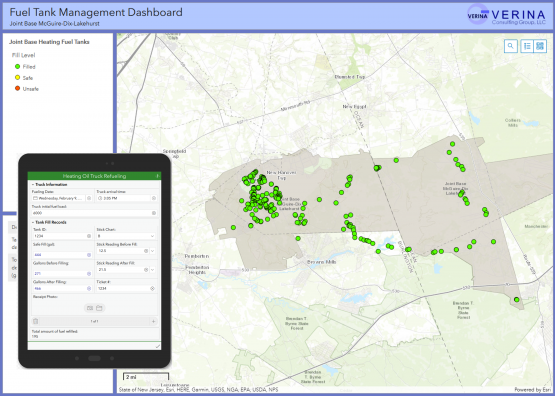
Environmental projects often require robust use of maps, GPS location data, and tabular data records. Geospatial data allows clients and regulators to get a comprehensive picture of site conditions and get useful information from data. VERINA offers services to manage and analyze geographic data. Our GIS mapping and data management services provide consolidation of information and improved understanding of each data set and how it relates to other data within a spatial and temporal context.
GIS Mapping Services
Our GIS mapping services allow visualizing and understanding data by identifying relationships, patterns, and trends by providing a digital platform for viewing and processing layers of spatial information. We offer a unique foundation of modelling, environmental and asset management experience supported by a proven track record of GIS systems.
VERINA continuously develops innovative tools to ensure effective project specific applications. We work with clients to meet their specific needs. These tools analyze and relate complex data sets and provide a unique visual experience for clients.
Data Management
VERINA’s expertise supports clients during feasibility and constraints analysis, site selection, data collation and management as well as data interpretation and analysis, data conversion, integration and interoperability and real time monitoring. These may include interactive web-based GIS solutions, document management systems and/or asset management systems for survey data, monitoring data, modelling data and data from third parties.